|
Ice profiling page 2 |
|
|
|
Ice profiling page 2 |
|
|
|
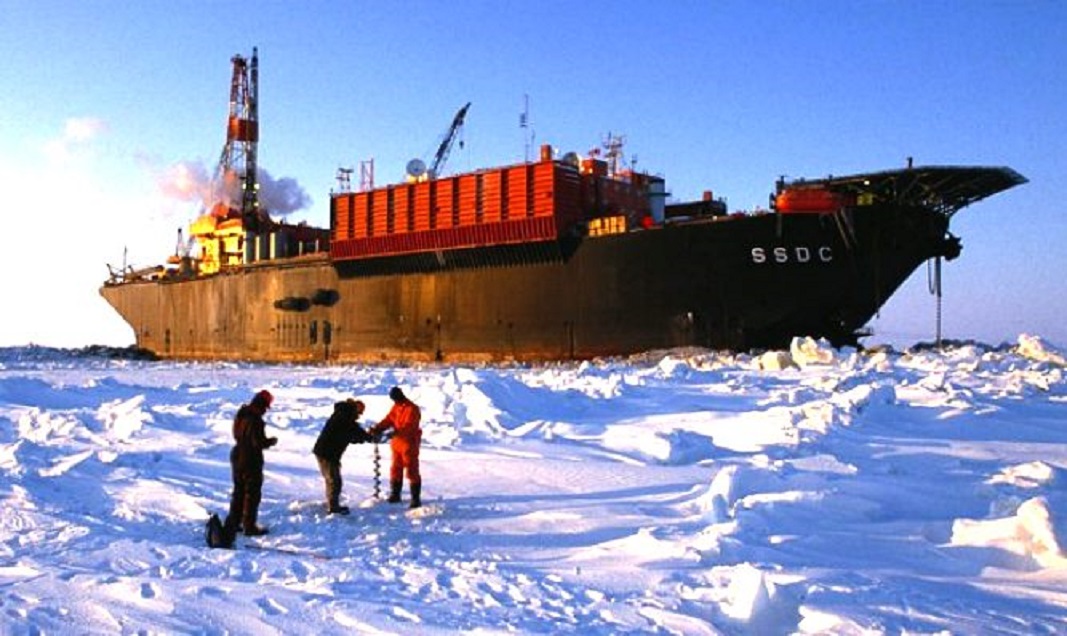
We would collect data and others folks on the “profile team” would process the data and produce maps indicating ice thickness….The client got maps of yesterday’s profile…… Note; on this Devon 05 project we did not produce maps as this is “late season ice” which is ice profiler code for thick ice. We were tasked with profiling a road to the SSDC and our main focus was thinner ice and cracks. Once the road was in place we may have had made maps…. can’t remember. Randy (Sadly I can’t remember his last name) from Devon, got us together and asked what would be the best way to do this profile. Good question. Not many people have been building ice roads out past the end of Mackenzie Delta; not since the 1970’s 1980’s. All the work I have been doing was all contained within the delta. ESSO and others were out there building roads back in the day but the craft and people were long gone. Up to this point all my ice experience had me on fresh water rivers and lakes. No problem for me to profile down the Mackenzie River to the outer north boundary, but going out into the ocean had all sorts of new tricks. I went looking for people who worked those ice roads back in the ESSO days and I found a nice fellow working at Northwestel in Inuvik. He told me they would push a road one day come back the next finding the transitional ice would cut the road and move it 500 feet to the west. I had only a couple experiences with ocean ice up until the Devon 05 Profile. During the Dome Petroleum days in winter 1982/83 I was driving a flat-deck Kenworth with a pup trailer and a HIAB. The job was to haul groceries on a ice road out to the “Dome Exploration Fleet” at McKinley Bay. McKinley Bay is east along the coast from Tuktoyaktuk and I saw some crazy “ice happenings” making those trips. Thankfully the ice road to McKinley Bay passed along the coast line and did not head straight off out across the ocean. No real Ice Profiling back then like we have today, just auguring holes, a measuring stick and writing down the information. Salt water ice on the ocean moves with currents, winds, pressures, etc. and as the winter season progresses the ice will become land fast. The ice stops moving and it becomes attached to the main land. Thankfully the ice had already become “land Fast” at The SSDC for our profile. Someone some where was planning on our behalf. Note; after we reached the SSDC and the initial profile was complete I met the “Ice Scientist” (Sadly I can’t remember his name). He was stationed on the SSDC and I wish I had met him before we started our project. He was a wealth of knowledge and really helped me with ocean ice. What I learned was “how much I did not know”. He had sequential satellite photos of the ice that was moving past the SSDC while the ice was in transition. His main function was at an end because the “transitional ice” had become “land fast”; as he said “the pressure was off”… so to speak. The Ice profile plan we made with Randy was; two snow cats, two snow-machines, one helicopter and good weather. We are able to talk to Randy on our radios as he is flying about. His job is to direct us from the air as to the best way to proceed. There were many more people and companies involved in this road build and this is just a small glimpse of a full road building program. This is just what I saw from my angle and here are some pictures to help show the course of events. All the best, Jay Hambleton. |
| Profiling Page 1 | |
| Profiling Page 2 | |